San Mateo, Calif.

This year, I set aside a day of vacation to unpack the car, do laundry, and ready to go back to work. Those tasks left me a few hours to begin dealing with the papers and photos I had brought back with me; I had sorted through most of Dad’s papers and photos while in Massachusetts, but I still had a couple of boxes to sort through, scanning those that were worth saving.

I started with the easiest task. While in Massachusetts, I had divided Dad’s photos up among his three children; if a photo featured one of us prominently, I gave it to that child; and the other photos I divided randomly and evenly among us. The easiest task was this: take my share of the photos, sort them in chronological order, and put them into a photo album. That took me a couple of hours, and I showed Carol the photo album, and then I looked through it again on my own. When I had done all this, I was pretty sad — the worst part was looking at the photos of my mother the year before she died; I had forgotten how bad she looked — but I was nevertheless glad I had done it. I realized, too, that most of these photos just sat in boxes for years and years, for decades even, and we never looked at them. Now even if I don’t want to look through that photo album ever again, at least I have the option to do so, and that feels like a minor accomplishment.

And that, I guess, is the real end to this summer’s road trip.

Winnemucca, Nev., to San Mateo, Calif.

Winnemucca lies at about 4,200 feet above sea level, has a desert climate with about eight inches of precipitation a year, is the only incorporated city in Humboldt County, and has itself a population of only about 7,400 people; as a result, the air is clean and fresh. I felt groggy when I awoke — too many days of driving this week, and too many hours of dealing with Dad’s papers last week have taken their toll — but I got up to go get a cup of coffee, and as soon as I had taken a few breaths of that cool, clean desert air, before I had even had any caffeine, I felt alive and awake and ready to go.

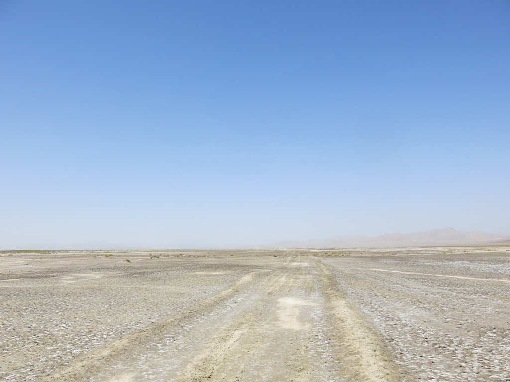
I headed west on Interstate 80, then south on U.S. 95. Just after I had made the turn onto U.S. 95, a two-lane highway with a 70 mile an hour speed limit, I saw a little sign that read “California Trail / Auto Tour Route / Truckee Route,” and I could see a rough track running west through the desert. I found a place to turn around, and walked out along the track into the desert.

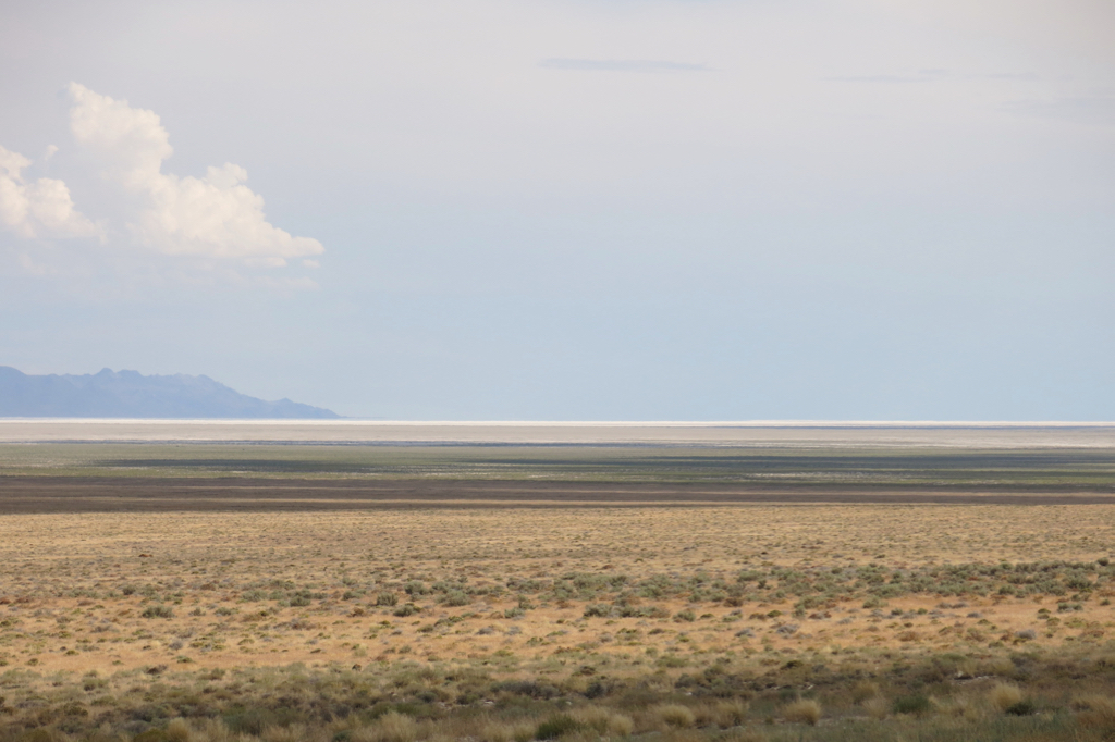
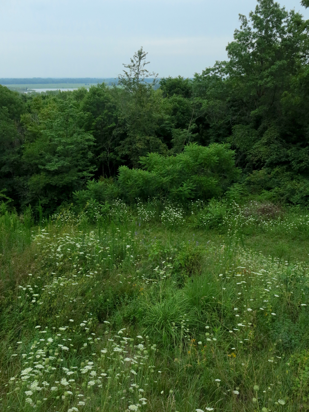
Maybe this track followed the route of the original California Trail turn-off to Truckee, the route the Donner Party followed to its cannibalistic end in the Sierra Nevada Mountains, but the tracks that were visible were those of twenty-first century off-road vehicles. The temperature was now up to about ninety degrees, but the air was still fresh and dry, and I walked briskly along for for a mile or so until my car was a speck in the distance. It must have rained yesterday, for the whitish soil was still damp, and my feet crunched pleasantly on a dry crust that had formed on top of the moist soil. Black, red, and buff-colored igneous rocks were scattered on the surface of the soil, many of them with air bubbles in the rock.

As I drove away from where I had parked, I saw that just south of where I had got out and walked, the highway crossed over a small ditch with open water in it. Perhaps this was why Truckee Route followed this particular path across the desert, following that dry wash that sometimes had water in it.

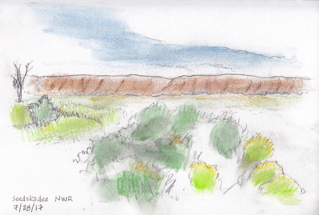
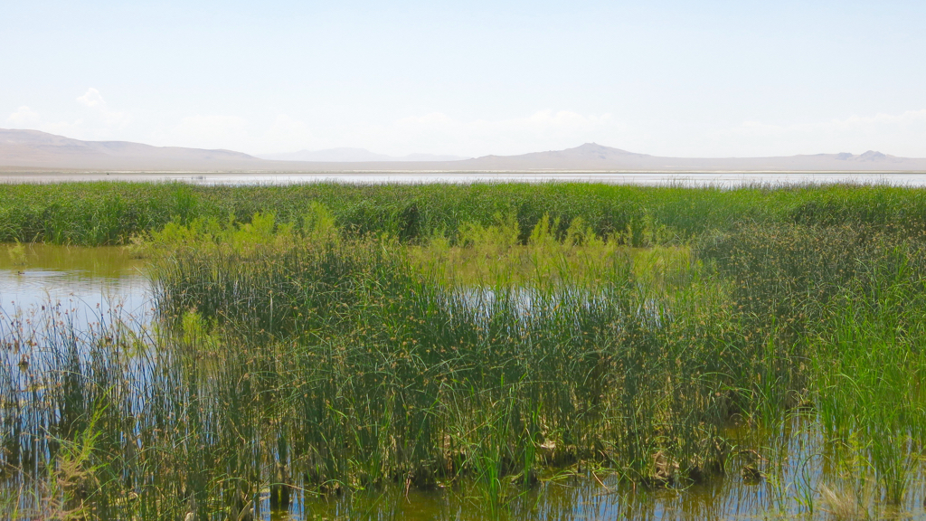
I stopped at Stillwater National Wildlife Refuge east of Fallon, Nevada, and it was just as I remembered it: a stunning oasis of open water and green wetlands. The difference this time was that Stillwater Reservoir had water in it; when I was here a couple of years ago, the reservoir had been dry. The open water, the green tule rushes and cattails, and the loud calls of a myriad of birds — squawking White-faced Ibis, grunting and hooting American Coots, booming American Bittern, quacking Blue-winged Teal and Cinnamon Teal, screaming Red-winged Blackbirds — contrasted bizarrely with the quiet of the reddish desert mountains in the distance and the serene blue sky overhead.

On my way through Fallon, I stopped at the bookstore in town, Third Space Books, and had a long talk with one of the owners, who turned out to be an early childhood educator who was worked with troubled adolescents during the summer. She was pursuing her doctorate of education online, and I asked about her online program and how she liked it. Aside from the obvious point that it obviously made more sense for her to get her degree online than driving an hour each way to study at the University of Nevada in Reno while holding down a full-time job in education, she also preferred online learning.

From Fallon, I drove up over the Sierra Nevadas towards home. As usual, I stopped at the Donner Pass rest area, and took the trail from the rest area towards the Pacific Crest Trail, where I ran into a long-haul trucker who was taking a break from driving. He said that while he had stopped at that rest area many times, it had always been at night, and this was the first time he had seen it during the daylight. “Where does that trail go?” he asked, and I said, “Pretty soon it meets another trail, and if you turn left you can walk to Canada, and if you turn right you can walk to Mexico.” His eyes widened, and he clearly thought I was putting him on, so I added, “I’m not making this up,” and explained to him about the Pacific Crest Trail. He said he’d like to return sometime with his thirteen year old son, who sometimes came with him on these trips. On the other hand, he also said that he didn’t like driving through Nevada because there were casinos and slot machines everywhere, and he had lost too much money gambling earlier in the day, and he was thinking of asking his boss to only send him along the southern route, via Interstate 40.

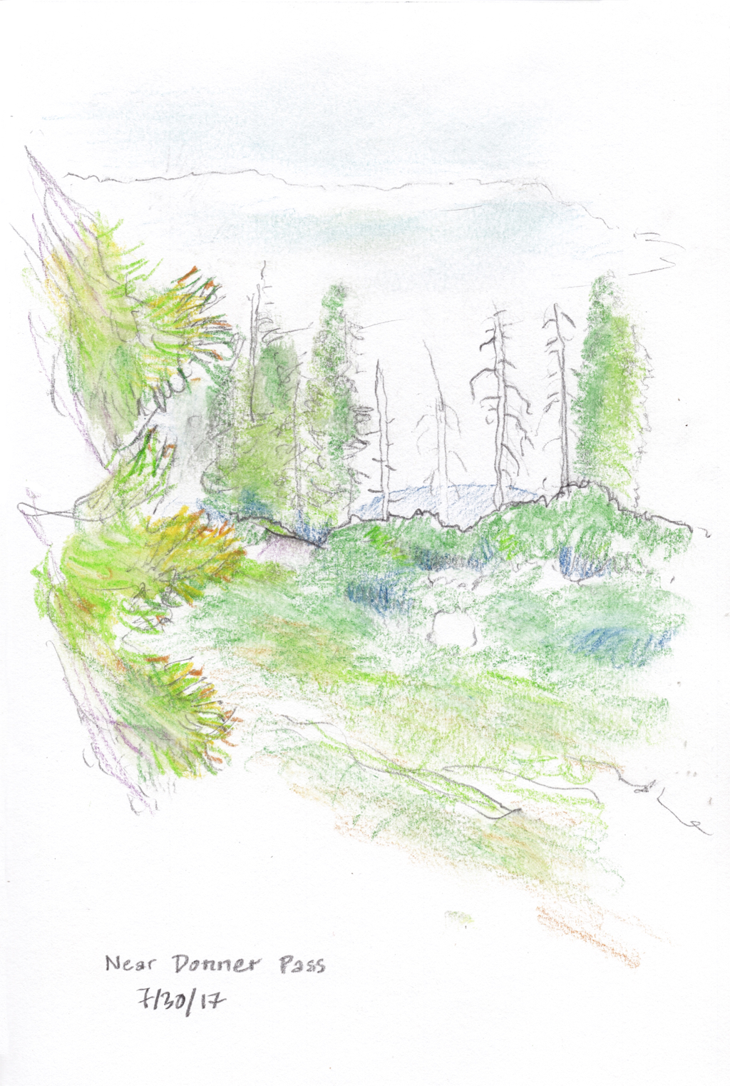
We said goodbye, and he walked abck to his truck while I walked out into the alpine forest that is slowly. What struck me most were the many tall white skeletons of dead pine trees which stand out among the remaining green trees. The Sierras have been ravaged by bark beetles, a native species that can kill trees that are stressed by drought. According to a March 28, 2015, article in the San Francisco Chronicle, “The beetle population is normally kept in check by the winter cold, but three years of above-average temperatures and lack of snowfall have given the growing bug hordes free rein to search and destroy.” This is yet another effect of global climate change. This past winter was cold and snowy, providing a respite for the trees this summer; but the trend of global climate change means that the bark beetle problem will soon return. I stood there and made a sketch: a few bleached trees standing out from trees and undergrowth that are bright green for now.

I briefly fantasized about continuing to walk along the Pacific Crest Trail, heading for Canada. But instead, I turned around and headed back to my car.

Note: Written on 8/2 from my notes.

Evanston, Wyo., to Winnemucca, Nev.

When I got up, the air felt cool, clean, thin, and bracing. The temperature this morning was in the low sixties; Evanston lies far from any major city or industry or source of heavy air pollution; the city is some 6,750 feet above sea level, so the air is much thinner than the sea level air I’m used to; and the combined effect made me feel cheerful, alert, and a little light-headed. I decided to take a walk in Evanston before I started the day’s long drive; Bear River State Park was just minutes from my motel, and soon I was walking along the Bear River. I left my binoculars in the car, because I needed to walk, not stand and look at birds; and of course there were many birds in the marshes and willows and green grassy fields around the river, and I soon wished I had brought the binoculars, but I managed to walk briskly for an hour without them.

As I drove down the highway towards Salt Lake City, I couldn’t decide which route to take. About an hour from Evanston, I stopped at a rest area that had Utah tourist information. There was a brochure for Bear River Migratory Bird Refuge — a different Bear River from the one I walked beside in Evanston, this was a Bear River in Utah that empties into Great Salt Lake. So instead of going through Salt Lake City and then driving west across the salt flats, I went north towards Idaho, got off the highway at Brigham City, Utah, and headed west to the auto tour route of the Bear River Refuge.

I generally dislike auto tour routes; I don’t like sitting in my car to look for birds, I prefer to get out and walk around. But this auto tour route proved to be exceptionally beautiful: driving on dikes through the Bear River delta, the flatness of Great Salt Lake to the south, the dry flat plain gradually rising up from the Lake to the north and east, towering mountains appearing at a distance in all directions, bright sun coming down through the dry, incredibly clear desert air; and all around the dike on which I drove was the incongruous sight of water in the middle of the desert.

I spent two hours driving along the auto tour route, getting out frequently to to look at birds, or admire the landscape, or for no real reason at all. Had I had all day to spend, I would have liked to have walked all twelve miles of the auto tour route. But as it was, my average speed was just six miles an hour: plenty of time to see adult Western Grebes swimming with their fuzzy babies, and Cliff Swallow nests, and half a dozen American White Pelicans soaring in formation over the open water of the marsh.

From the refuge, I drove north on Utah Highway 82, past the turnoff for Promontory Point, past Orbital ATK with its exhibit of a huge NASA rocket, drove on the interstate for a few miles, then headed west on Utah Highway 30. A sign informed me that there were no services for the next 100 miles. There was very little to see but vast plains, sudden steep hills, mountains in the distance, and the slowly gathering clouds in the sky overhead. I drove through the village of Park Valley, where the Overland Trail Motel had once sold gas but was now closed, and saw two children riding horses up and down a large mound of dirt. More plains and cattle and carefully irrigated hayfields, then the hamlet of Rosette with a tiny post office. The road turned south towards the north edge of the great salt flats, and I stopped to stretch my legs — it had been a long time since I had left Bear River Refuge — and looked out over the salt flats in the distance. The plain I stood on tilted downhill, but when it met the perfectly level salt flats I had the impression that the salt flats were tilting up and away from me. Then the salt flats are so vast that you become aware of the curvature of the earth’s surface. I guessed I could see for a hundred miles or more. I am not used to seeing that far on land, and I found it disconcerting.

I kept driving across the open landscape, resentful if I saw another car — which was not often — feeling very much at peace. I realized that I had not wanted to drive through Salt Lake City, so even though this route was longer and slower, I was very glad I had come this way. At last I rejoined the interstate highway in Oasis, Nevada, and though there weren’t many vehicles on it, it felt busy and crowded. I am not looking forward to plunging back into the bustle of city life when I return home tomorrow.

At Pequop Summit, I pulled over to stretch my legs again. It started raining. It wasn’t a heavy rain, or a hard rain, but it was a steady light rain. The sage brush smelled strongly in the rain. I had to try to photograph rain in the middle of the Nevada desert, though you can’t see any evidence of rain in the photo — the air was so dry the pavement didn’t get wet — all you can see is dark clouds. There was a roll of thunder, and I got back in my car and continued driving west.

Notes:

If I ever return to the area north of the salt flats, I’d like to go see Nancy Holt’s huge environmental artwork “Sun Tunnels,” about ten miles south of Utah highway 30.

I ate dinner at a Chinese restaurant in Elko, Nev., and the fortune inside the fortune cookie read: “You desire to discover new frontiers. It’s time to travel.” — an ironic fortune to receive when I’m about to end my travels and return to work.

Sidney, Neb., to Evanston, Wyo.

In the motel parking lot this morning, two women were re-packing the car next to mine, while a toddler sat quietly in the back seat, sucking at a bottle of milk. One of the two women was a couple of years older than I, and she was moving from South Carolina to Portland, Oregon, to be near her daughter — the other woman in the car — and her grandson — the toddler. So the car was full of her belongings. I told her that I had been in Massachusetts helping my sister dispose of the last of my father’s belongings, so my car was full of stuff, too. We got into a long talk about moving, and people dying, and other such mournful topics that are so satisfying when you get into your fifties, while the young woman pretty much ignored us, and worked on repacking the car. We said something to her about how she probably found this kind of talk boring, and she politely refrained from rolling her eyes and said something noncommittal. Her mother said, “She’s in her twenties, she’s still young.” I said to the young woman, “I’ll bet you don’t feel young.” “No,” she said, “I don’t.”

I drove all day, and at about six o’clock pulled into one of the several entrance roads to Seedskadee National Wildlife Refuge. I had thought about going to someplace new and different, but after being so disappointed with yesterday’s visit to a new and different place I decided I’d go to a place I knew I liked. I walked a mile and a half down a dirt road alongside the Green River, looking out at the marshes and trees along the edges of the river. And then I walked back, this time looking in the opposite direction, out over the sage brush and up at the heavily eroded bluffs a mile or so back from the river. Some Sage Sparrows flew over my head, singing their funny little tsee-tsit-sit song as they went over.

It’s certainly not a wilderness experience. The county highway is a mile away but you can see it clearly over the flat sage plain; and the huge white above-ground infrastructure for Ciner Wyoming, a company that mines soda ash, is clearly visible ten miles to the south. But there is something very satisfying about the swift Green River, and its verdant marshes and trees, flowing in the middle of the arid sage brush plains, with steep bluffs well back from each side of the river, and in the far distance glimpses of snow-covered mountains. There is something about the elevation, something like seven thousand feet above sea level, and the dryness of the air, and the clarity of vision that comes with both these things. And there’s something about the sage brush, and the big ant hills among the sage, and the rocky alluvial soil under the sage.

The sun began to move lower in the sky, and I knew I had to leave. Some day, I promised myself, some day I’ll come back and spend a week or two here — but I don’t feel any need to keep that promise; it was enough to just think about it.

Avoca, Ia., to Sidney, Neb.

I drove into DeSoto National Wildlife Refuge at about ten o’clock. The refuge comprises an oxbow bend of the Missouri River that had been cut off by the Army Corps of Engineers in order to shorten the main navigation channel. I had high hopes for DeSoto National Wildlife Refuge, but it had been over-developed, with carefully graded and graveled paths, and easy-to-drive roads, and large buildings, and distant refuge staffers who obviously saw too many tourists each day to want to spend more than the minimum time talking. The oxbow bend had been channelized by the Army Corps of Engineers before it had been cut off, and it too looked carefully arranged. I spent an hour and a half walking the short, easy-to-walk trail and looking for birds, and then I drove through the rest of the refuge, and as I drove back to the interstate I was just as happy to leave the refuge behind.

That unsatisfactory visit left me with no time to do anything during the rest of the day but drive, and listen to Great Expectations. As Great Expectations progresses, the impossible coincidences pile up, but the characters feel real, and the moral force of the book feels real, and so the coincidences of the plot quickly fade out of consciousness.

As I drove across Nebraska, the Midwestern Prairie gave way to the Great Plains, and the sky loomed larger and larger, and made me feel less and less consequential. Just before I got to Sidney, I pulled over at a rest area to check the directions to the motel. A large thunderhead towered to the south, to my left, and the sky to the north was covered in thick black roiling clouds lit from within every once in a while with a weird sickly orangey-yellow light. I got out to make a sketch of the thundercloud to my left, with the tiny new moon visible to the west in a patch of sky that was yet clear. I had done only a quick sketch when a gust of wind hit the trees behind me, and then a gust of wind hit me, carrying spattered rain drops, and I ran and got back in the car. The car rocked with the wind as I drove towards Sidney. Another spattering of light rain hit me as I got out of the car to check into the motel — but that was all; the main force of the storm passed to the north, and I was able to carry my luggage inside without getting wet.

Joliet, Ill., to Avoca, Ia.

I made a detour to Port Louisa National Wildlife Refuge, along the Mississippi River about six miles north of Wapello, Iowa. It was 86 degrees when I arrived, and the dew point was probably in the low seventies: the air was warm and moist and smelled of fields and river bottomlands. I walked down the bluff to the bottomland. There was standing water not far from the trail, which the map told me was Little Goose Pond, a back water of the Mississippi River. Four Double-crested Cormorants sat in the topmost branches of a dead tree on the opposite shore of the back water, their mouths gaping open for no apparent reason. But I didn’t see many birds; mostly I heard birds, and often I couldn’t be sure what they were; I’ve left behind the eastern woodlands and moved into the prairies and plains of the middle of the continent, an ecological stage with a somewhat different cast of characters.

I stopped to talk to a member of the refuge staff who was cutting brush, aided by two summer interns. “Have you seen many birds?” he asked, looking at the binoculars hanging around my neck. “I haven’t seen many different taxa,” I said, “but I have seen quite a few individuals. Like there were about twenty Wood Ducks back there.” At this, one of the interns perked up. “Twenty?” he asked, somewhat skeptical. “I didn’t see them all, but I heard them,” I told him. We talked about Wood Ducks a bit, then the intern turned and pointed in the woods. “A deer.” I almost didn’t see it, skulking through the woods a good hundred yards away.

Back at the top of the bluffs, I was dripping with sweat. A few drops of light rain falling didn’t cool me off. I turned to look over the broad wooded bottomlands along the Mississippi, wishing I had an entire day to spend there.

At a rest area west of Des Moines, I stopped because a blade from a wind turbine had been erected there. A plaque said it was 148 feet tall. The children playing on the playground below it, and the picnickers sitting at tables near it, made it look much bigger than the same-sized blades slowly turning on wind turbines on the ridge above.

I pulled into Avoca at nine o’clock, and took a moment to watch the light fade over the steeply rolling hills to the west. The air temperature was just about at the dew point; mist began to gather where the land was lowest; the windows on the car were quickly covered with dew; and in the western distance it became hard to tell where the land stopped and the clouds started.

Macedonia, O., to Joliet, Ill.

After two days of getting lots of sleep and still needing two naps a day and some minor aches and pains, I concluded I must have a little infection. My prescription for myself is: drink plenty of water, get plenty of sleep, take acetaminophen when needed, and take it slow.

On the trip out I saw a sign that read “Indian Mounds,” and on this return trip I decided to see them. I followed the sign until I wasn’t sure which way to go, and stopped to ask at a small roadside store. While I picked out something to drink, I listened to three women having a conversation. One woman was telling about her ugly drivers license photo. “When I get rid of this baby fat,” she said, hitching a small baby up higher on her hip, “I’m going to lose my drivers license so I can get a new one.” “You don’t have to do that,” said the woman behind the counter. “You’d know what I mean if you ever saw my drivers license photo,” said the woman with the baby grimly, and went out to her car.

I went to the counter to buy my drink, told the two remaining women that I was a tourist and wanted to see the Indian mounds. “Right up that street,” said the woman behind the counter, “You’ll see the sign. And you should know that this lake here,” pointing out behind the store to where there was a small lake, “is the largest natural lake in Ohio.” I promised to look at the lake, and said that it seemed like it was a nice place to live around there. Both women agreed. “It’s a little slow, though,” said the woman behind the counter, “We like to watch paint dry.” I said that sounded good to me.

The Indian mounds were small: about two or three feet high, and maybe fifteen feet in diameter. A sign said they were burial mounds probably left by the Hopewell people — the qualifier “probably” was necessary because pot hunters and grave robbers had plundered the mounds and had not adequately documented their finds. Even though the mounds were small, I felt that romance attached to them: they were visible signs of a people who had lived two thousand years ago, and I wondered what the land was like then, what they saw and thought about and felt.

I stopped to look at Nettle Lake on my way back to the interstate highway. From where I stood I couldn’t see the whole lake, but estimated what I saw to cover about 50 acres (I looked it up, and found I could only see about half the lake; the total area is 115 acres). It was a pretty lake, filling a hollow left by the ancient glacier, with small houses and mowed lawns all around the edge.

The toll road through Indiana was as dreary as always. But on this trip, I’m listening to Great Expectations by Charles Dickens, and it’s such an engaging book that the miles passed by quickly.

I knew I was going to hit Chicago at rush hour, so I detoured up to Grand Mere State Park in Michigan. The park includes a couple of miles of shoreline on Lake Michigan, as well as three inland lakes formed in depressions left by the glacier. But the one inland lake I saw, South Lake, has mostly filled in so that there is almost no open water in it. I know this, because I climbed up one of the sand dunes that lie between Lake Michigan and the inland lakes. This sand dune was at least a couple of hundred feet high, covered with trees and dune grass. Parts of the trail were steep enough that I could reach out and touch the sand in front of me while hiking; and the hiking was so difficult in the loose, sliding sand of the trail up that I dug my hands in and used them to help my slow upward progress. I had to stop several times to catch my breath, but when I got to the top the view was worth it: the mostly overgrown inland lake to the east, and wide shining grey Lake Michigan to the west.

Then I slid down the other side, and and sat and admired the dramatic lake shore: huge wooded sand dunes on my right, a wide beach covered with dune grass in front of me, the wide lake spreading out to my left.

I walked north along the lake, and climbed back over the wooded dunes, this time on an easier trail. My legs were sore by the time I got to my car.

And then I drove on, dodging the insane Chicago drivers, to arrive in Joliet at nine o’clock.

Rochester, N.Y., to Hudson, Ohio

The bookstore for the Rochester Institute of Technology was a five minutes drive from last night’s motel, so I stopped there on my way to the interstate. In five minutes of browsing, I found Bumble Bees of North America by Paul Williams, et al. I’m fascinated with Hymenoptera (bees and wasps) to begin with, and as the first sentence of the book says, “Everybody likes bumblebees.” At every rest stop during today’s drive I read about bumblebees, genus Bombus, and every bit of it was fascinating reading; though I was discouraged to learn that distinguishing some Bombus species requires looking at details like the structure of male genatalia and learning terms like “midleg basitarsus distal posterior corner.”

The book about bumblebees was the only interesting part of today’s drive; I had no time to stop anywhere along the way, because I planned to meet my uncle in the mid-afternoon. But the visit with my uncle was well worth the boring drive. We had a long talk, mostly about the younger members of the extended family, we ate dinner together, and then before I went back to the motel we called my cousin E. to ask her about the recent death of cousin C. He had had an unpleasant illness, and his death came more quickly than expected. This call was a somber end to what was otherwise an upbeat visit; but this is simply part of the experience of upper middle age; people that you’ve known for decades start to die off; and of course the number of such deaths will only increase, and their pace accelerate, and the thing to do (I can see from watching people like my uncle) is to acknowledge the deaths but not let them take over your sense of being; to keep the focus of one’s attention on growth and life rather than on death and decay.

Now I really have to get to bed early, so I can get on the road at a decent hour tomorrow morning. But first I want to read some more about bumblebees.

Eastern Mass. to Rochester, N.Y.

I left my sister’s house this morning, and started driving west. By late morning I was in the Berkshires in western Massachusetts, and I couldn’t stand sitting in the car any more, so I got off the highway to go for an hour and a half walk on the Appalachian Trail. I parked in Beckett, Mass., and started walking, following the famous white blazes south.

There’s a footbridge for the Appalachian Trail over the interstate, and I’ve driven under it many times; now at last I was walking across it, watching the cars speed by under my feet. The trail climbed up into the woods, and a Wood Thrush sang in the trees. The traffic noise grew fainter and fainter, until at last it faded completely away. Black-throated Green Warblers and Red-eyed Vireos sang their monotonous songs in the trees above me. All too soon, it was time for me to turn back, and reluctantly I headed back downhill to the car.

The rest of the day was boring: driving, stopping at rest areas, a couple of naps in the car because I was still tired from dealing with Dad’s estate. I went to the wrong place in Rochester, and when I finally got to the correct hotel and checked my voice mail I got a message from one of my cousins that another of our cousins had died after a long illness.

Eastern Massachusetts

I spent the week at my younger sister’s house going through Dad’s papers, figuring out what needs to be saved. Each morning before we started working, I drove to Great Meadows National Wildlife Refuge in Concord, Mass., to spend a couple of hours birding.

On the first day I went there, another birder pointed out where a Ruby-throated Hummingbird was nesting. The mother would come once or twice an hour to feed the young. When they saw or heard she was near, they pointed their bills straight up, and opened their mouths. She perched on the edge of the nest, and put her long bill down into the mouth of one baby, far enough down that I could not see the end of her bill. Presumably she regurgitated nectar that she had gathered. She alternated between nestlings, putting her bill into each nestling’s mouth three or four times during a feeding.

Over the course of the week, pin feathers gradually replaced downy feathers on the nestlings; on Friday, the last day I made it to Great Meadows, the nestlings were spreading their wings. By now they may well have fledged, and left the nest. Also on Friday, I saw a Least Sandpiper, which must be one of the early shorebirds to return from the far north where it nested, gradually making its way south for the winter, stopping here and there to feed heavily. With the hummingbird nestlings about to fledge, and the shorebirds heading south, it felt like the season was turning: summer was past its peak and heading towards autumn.

My sister and I finished going through Dad’s paperwork, and closed out the checking account for the estate. There is very little left to do, except shred his financial and medical records. And tomorrow I start driving back to California.