Joliet, Ill., to Kearney, Neb.

We started driving at nine in the morning, quickly leaving behind the crowded roads of Chicagoland.

Water towers are prominent features of the midwestern landscape, and traditionally the municipality that owns the water tower will paint its name on the side. Stuart, Iowa, has updated this tradition: a large white wind turbine had “STUART” painted in large letters down the tall tower.

We stopped at a rest area west of Des Moines, and as I looked out at a large field of corn I couldn’t help comparing the ecological characteristics of corn fields with lawns. Both crops cover large areas of North America (one source says that lawns cover more land area than any other single crop). Both crops are raised as monocultures that require huge amounts of chemical fertilizer and chemical controls for weeds and pests. Considered from the point of view of ecological science, both lawns and corn fields support a low density of species; and the “insurance hypothesis” predicts that lawns and corn fields will be relatively vulnerable to changes such as drought, invasive species, pest infestations, etc.

BlogJul2314a

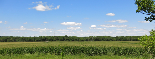
Above: Corn field near a rest stop west of Des Moines

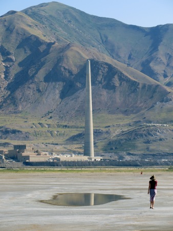
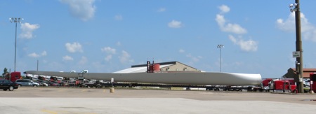
As we drove by the Adair wind farm on Interstate 80, we could see a highway rest area with a tall white monument in front of it. As we passed it, we realized it wasn’t a monument at all: it was a wind turbine blade standing upright.

We decided to stop in Omaha for dinner. Carol found what sounded like a good restaurant, McFoster’s Natural Restaurant, using her smartphone. When we got there, we realized we had been at that restaurant some years earlier. At that time, the restroom walls had been covered with stickers, so Carol stuck one of her own stickers on the wall: a yellow spiral with the words “Urine Charge, Take Life Full Circle.” Alas, the restrooms had been renovated, and all the stickers were gone.

As we sat eating dinner, a couple in their early twenties walked in. The woman was saying to the man, “Yeah, I don’t know if you’ll like this place, but it’s my favorite restaurant. If you don’t like it, we can go somewhere else.” When they were out of earshot, Carol said aloud what I had been thinking: unless they were brother and sister, the man had better at least pretend that he liked that restaurant. As we were walking to our car, we saw them coming out of the restaurant; they both seemed to be in a good mood.

We had a long way to go, so we got in the car and kept driving west, into the setting sun….

BlogJul2314b

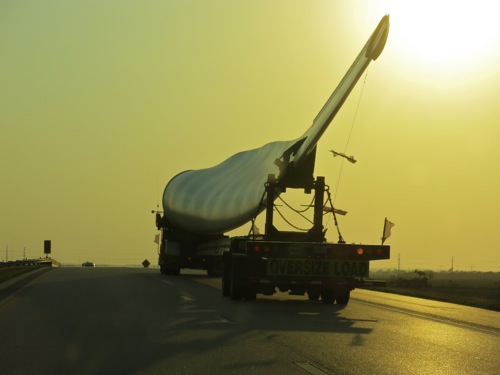
Above: Wind turbine on Interstate 80 in Nebraska


BlogJul2314c

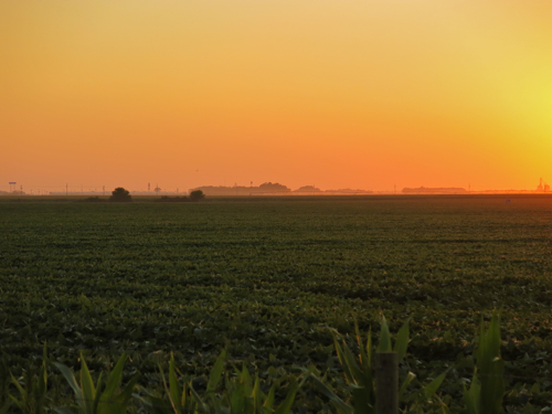
Above: Sun setting over a Nebraska soybean field

Rock Springs, Wyoming, to Elko, Nevada

By noon time, we had almost reached Fort Bridger, Wyoming, and we decided to go there for lunch. We took Business 80 through Lyman (population 2,115, elevation 6,706) and Urie (population 262, elevation 6,785), and thence into Fort Bridger (population 345, elevation 6,673) — three small towns spread along the broad green valley through which winds a narrow river. Jim Bridger, who established Fort Bridger, described the location in a letter from december, 1843: “The fort is in a beautiful location on Black’s Fork of Green River, receiving fine, fresh water from the snow on the Uinta Range. The streams are alive with mountain trout. It passes the fort in several channels, each lined with trees, kept alive by the moisture of the soil.” (quoted in R. S. Ellison, Fort Bridger: A Brief History [Wyoming State Archives, Museums, and Historical Department, 1931, 1981], p. 9)

We pulled in to the Fort Bridger State Historic Site and Museum, and asked the woman who collected our day use fee if there were a restaurant in town. She pointed across the street. We parked the car and walked across to Will-yum’s restaurant for a leisurely lunch — leisurely because neither we nor our waitress nor the owner and chief chef of Will-yum’s were in any great hurry.

The Fort Bridger State Historic Site proved to be very satisfying. It has remained untouched by modern curatorial trends, so there were no interactive displays, no over-researched,painfully-objective descriptive captions. Whoever set up the displays got us to use our imagination so that several different eras were brought to life: the original fort and trading post for the emigrant trains in the 1840s, the brief life of the Pony Express in 1860-1861, the U.S. military post in the 1880s, the tourist trade along the Lincoln Highway in the 1930s. I think my favorite part was the Black and Orange Cabins, a motel built in 1929, which is mostly restored. Kelvin Hoover, a costumed guide, showed us around. You can look in the windows of the cabins and see what it might have been like had you stayed in one in the 1930s: the tiny little wood stove with a kettle on it, the simple wood shelves, an old-fashioned Edison light bulb hanging from the ceiling. Each cabin had its own open garage, and there was a small power plant to generate electricity for the lights, but you had to walk down to the end of the cabins to use the outhouse.

BlogJul2013

Kelvin Hoover in front of Cabin no. 1 (photo credit: Carol Steinfeld)

As we drove west through Wyoming, we saw fewer cattle. We saw a few oil derricks, and mysterious industrial plants out in the middle of nowhere, and what appeared to be mines, and lots of wind turbines. I picked up a copy of the Wednesday, July 17, number of the weekly newspaper Green River Star, and found three articles by editor David Martin on wind farms; obviously wind farms are of growing importance in southwestern Wyoming. Martin reports that “Carbon County has nine wind farms comprising a total of 492 turbines,” and county commissioners in Sweetwater, Carbon, and Uinta counties continue to wrestle with how to regulate development of wind farms. The western landscape is not an empty wilderness, it is being heavily used by us humans for the extraction and exploitation of raw materials and energy.

In the late afternoon, we had gotten past Salt Lake City, and on a whim we pulled off the highway to see the Great Salt Lake. We pulled into the parking lot of Great Salt Lake Park and Saltair Beach. The water was a good distance from the parking lot, and we could see people walking out across the sand and mud towards the water. We started walking. The footing was mostly solid sand, but in places we had to walk through slippery sloppy mud a few inches deep; Carol was wearing flip-flops and she wailed that the mud was hot. The sun was hot, too, and the hot wind carried a distinctive odor, sort of like low tide. There were what appeared to be ice crystals in the mud at one point; but the crystals were salt, not ice.

When we were out near the water, I looked back at the Kennecott copper smelting plant and its huge smoke stack, over 1,000 feet tall. In the west, the stark beauty of the landscape is usually paired with some kind of crazy-ass human-built structure, often huge or sprawling, that’s so ugly it becomes stunningly beautiful:

BlogJul2013b

Joliet, Illinois, to Yankton, South Dakota

Once we left Joliet, it wasn’t far to the outer edge of Chicagoland, that vast sprawling patchwork of suburbia and small cities that extends outward an hour’s drive from Chicago itself. And once we got past Joliet, it felt like we left behind the hustle and bustle and density of the eastern third of the United States: traffic got lighter, the distance between cities became greater, it seemed as though I could feel the density of human beings grow less.

We crossed the Fox River. We used to live near the banks of the Fox River, quite a ways upstream from where we crossed it, ten blocks from the little 1842 stone church building, built of stone hauled up from the river bed in part by the minister, Augustus Conant, the second oldest Unitarian church building still standing west of the Alleghenies.

The miles rolled by. We drove through the barely rolling fields of central Illinois, past the Quad Cities, into the gently rolling land of Iowa, driving almost due west. As we drove, I thought about the dream I had had last night:

Have you climbed up the tower? All the way to the top six levels? someone said to me.
No.
They implied the climb would be spiritually rewarding. So I started to climb.
The first six levels I had already gone up and down: prosaic open-mesh iron staircases of the kind you find in old industrial plants, winding up through a rusted iron structure. Then the staircase from the sixth to the seventh level got very steep, and was behind an iron gate that creaked open.
Then I got into the seventh level. This was the children’s level. A woman I had known in high school sat talking with some children. Bright walls, interesting toys. I moved some mannequins or puppets or dolls made out of wire, to get at the moveable stair case that would get me to the next level.
The eighth level was the map level: it was a balcony around the children’s level, with maps in big wide chart drawers, with big windows above the drawers to look out at the sun setting over the city and landscape beyond….

It was at this point in the dream that the horrendously loud fire alarm went off in the motel. We stumbled around, preparing to get out of the building, when the alarm went silent. We went back to bed, and I began to dream again:

…The ninth level was reached by a steep staircase, the level of Eternal Night: galaxies, suns, darkness, whirling around, and it appeared that in the darkness two or three awe-struck people sat, but of that I couldn’t be sure. I did not stay long there, because it seemed to me that it would be easy to stay there forever.
The tenth level was the level of peace, a peace that surpassed understanding, a place to be in peace. One man sat zazen — I looked at him, and thought, a little scornfully, how stereotypical! — this was a place where peace permeated your being without some painful exercise. I did not stay long here, either.
The eleventh level was the library: low bookshelves all around the four walls, under big picture windows with the sun shining in, trees and birds singing. I wanted to spend a long time here.
The twelfth level: a woman on the stairs warned me that the air was thin. I climbed up the next few stairs. The air was indeed thin; ten thousand, maybe fourteen thousand feet above sea level. I had a hard time catching my breath, but it was a stunning view.

Thinking about such trivial things can occupy the mind for many hours while driving. If you chose, I suppose you could interpret this dream as having deep metaphorical meaning; I ignored any supposed meaning, and just enjoyed remembering it. Soon we stopped at the self-proclaimed largest truck stop in the world. While Carol was inside getting something to drink, I watched as truck pulling an incredibly long blade of a wind turbine held up traffic as it slowly maneuvered into the truck stop:

BlogJul1713

At the western edge of the loess hills of western Iowa, we pulled off at a sign that said “Scenic Viewpoint.” The entrance road wound up a knoll. We parked at the top, and climbed up half a dozen flights of steps made of pressure-treated two-by-twelves supported by telephone poles. At the top, we gazed around us: the broad valley of the Missouri River to the west, and to the north, east, and south, the loess hills rising two or even three hundred feet above the bottom of the valley. The tower swayed slightly in stronger gusts of wind, making me feel a little seasick. We were in a hurry to get to Yankton, to we climbed down and began driving again.

Heading north on Interstate 29, we drove through that broad valley of the Missouri River; through the strong smells of the rendering plants near Sioux City, winding along as we roughly paralleled the invisible river somewhere off to our left. After a time we left the interstate and headed due west, slowing down as we drove through the little college town of Vermilion, South Dakota, speeding up again on the other side until we reached Yankton. We ate dinner with Carol’s aunt, and I got to see pictures of Carol as a baby and a little girl.