Winnemucca, Nev., to San Mateo, Calif.

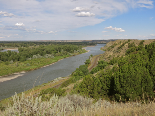
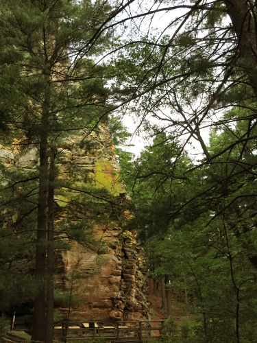
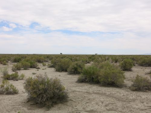
“At the border of the [Great American] Desert,” said Mark Twain, “lies Carson Lake, or The ‘Sink’ of the Carson, a shallow, melancholy sheet of water some eighty or a hundred miles in circumference. Carson River empties into it and is lost — sinks mysteriously into the earth and never appears in the light of the sun again — for the lake has no outlet whatever.” Although I had no interest in walking forty miles across the Great American Desert, without water, as Mark Twain had to do when he was taking the stage coach to Carson City, Nevada, I was interested in seeing the Carson Sink, so I left the interstate highway and drove down U.S. 95. There was no water in the Carson Sink when I drove through, just thousands of acres of bleak desolate salt-encrusted, dried-up mud. The Bonneville salt flats west of Great Salt Lake in Utah are pristine white and shine in the sun, and look sublimely beautiful; but the Carson Sink looks like dirty snow, with more dirt than snow, and looks merely grim.

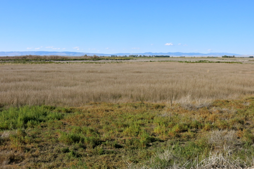
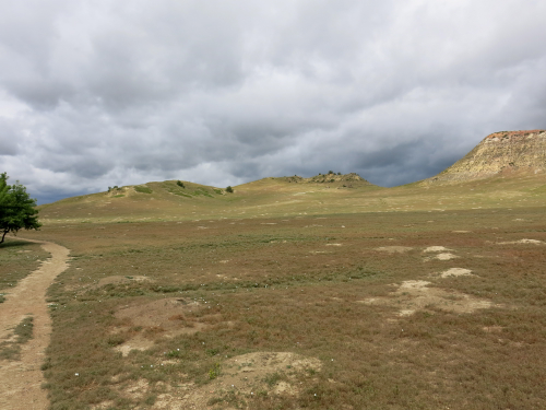
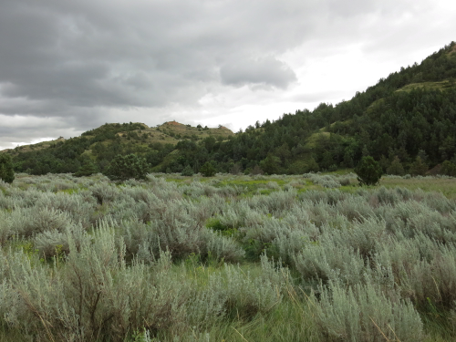
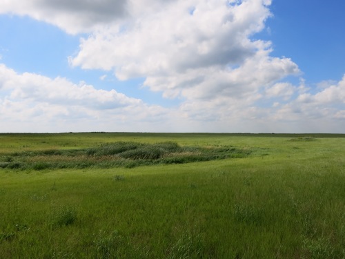
South of the Carson Sink, the land rose, and grew greener and greener, and there were ranches on either side of the highway, and then I was in Fallon, Nevada, the self-proclaimed “Oasis of Nevada.” I turned east on Nevada Route 116, drove some ten miles through hay fields and ranch lands, passed through the little hamlet of Stillwater, and then out into the 77,000 acre Stillwater National Wildlife Refuge. East of Stillwater, the land grew steadily drier and less hospitable, and it seemed like the only vegetation was clumps of black greasewood (Sarcobatus spp.).

Stillwater NWR, Sarcobatus spp.

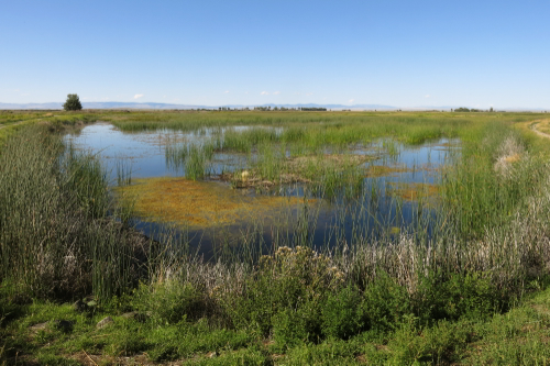
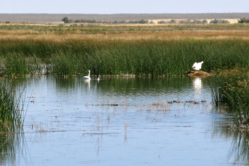
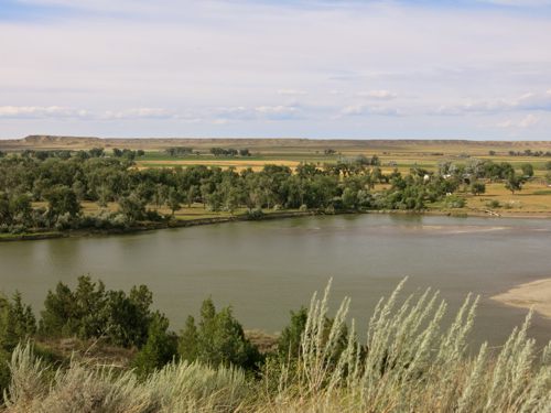
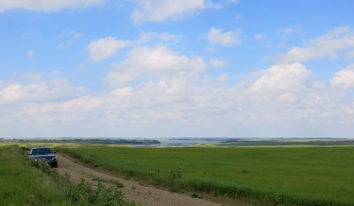
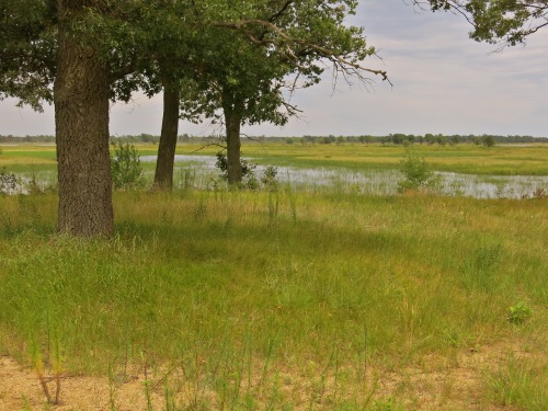
When I went around a bend in the road and suddenly saw open water, I thought at first that I was seeing those heat mirages so common in the Nevada desert. But no, it really was open water, surrounded by tule rushes and cattails.

BlogJul3115b

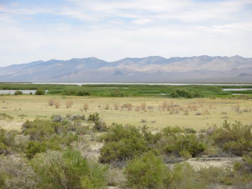
The Stillwater marshes provide breeding grounds for many birds, and I saw juveniles of several species, including American Coots, Eared Grebes, Pie-billed Grebes, Ruddy Ducks, and various kinds of swallows. I saw Great Blue Herons, Loggerhead Shrikes, Snowy Egrets, Virgina Rails, White Pelicans — and watching huge White Pelicans glide in graceful formation against the backdrop of distant rugged desert mountains was a sight worth seeing. There were other animals in and around the marsh, too — lizards, and some hidden animal, probably a muskrat, that moved noisily among the rushes just at water level about five feet from where I stood, and and half a dozen jackrabbits.

Jackrabbit, Stillwater NWR

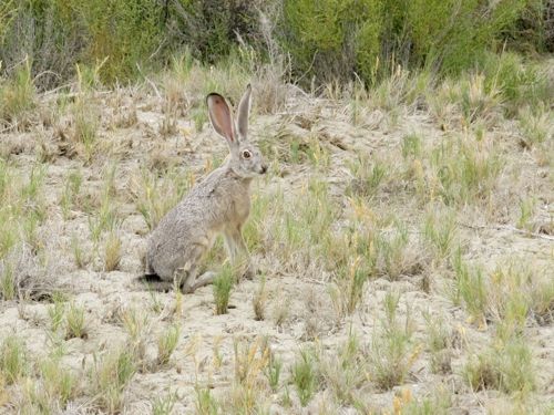
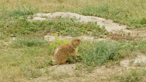
Mark Twain calls this animal a jackass rabbit: “He is well named. He is just like any other rabbit, except that he is from one third to twice as large, has longer legs in proportion to his size, and has the most preposterous ears that ever were mounted on any creature but a jackass.” One of the jackass rabbits I saw started from cover when I got too close, stopped when i froze and stared at me with big black and yellow pop-eyes, let me take a photograph of it, then started suddenly and bounded away and lost himself among the clumps of greasewood.

When I got to Stillwater National Wildlife Refuge, the sky was overcast, and the temperature was about 85 degrees — a very pleasant temperature in the dry desert air — but slowly the sun came out and the temperature climbed up to 97 degrees, and there wasn’t any shade to speak of, and I decided it was time to move on. When I sat in the car, almost instantly my back grew wet with sweat; it had been so dry that my sweat dried almost instantly as long as the air could get to me, but once the air was blocked off it soaked my shirt.

From North Dakota to central Nevada the highways are lightly traveled and there were many times when I couldn’t see another vehicle in front of me or behind me. But from Reno to the Bay Area, the highways are heavily traveled, and they wind and twist and go up and down abruptly, and I had to dodge the occasional crazed driver (all of whom seemed to have a California license plate) who thought it great sport to suddenly change lanes and dodge in front of me and slow down and speed up with no apparent rhyme or reason. Driving was no longer enjoyable, and I settled down to suffer.

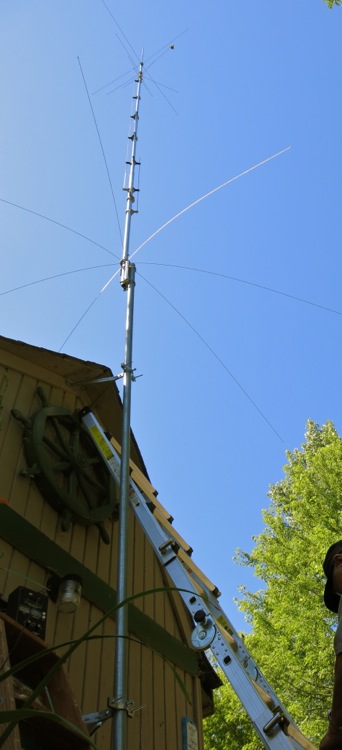
From Maine to California, I had periodically been monitoring 29.600 MHz, the amateur radio national calling frequency for FM simplex, and in all those miles and hours had heard nothing but static. The driving required too much of my attention to want to try to listen to an audiobook, so I turned on the little 10-meter band radio and started listening to static. Just east of Sacramento, I realized I was hearing someone giving a call sign with a Hawai’i prefix. I replied, he heard me, and I wound up talking to Norm, who lives on the Big Island, some 2,450 miles from Sacramento. Traffic got bad so I had to end the contact — and of course by the time traffic got more reasonable, ten miles west of Sacramento, I could no longer hear Norm, and there was nothing but static once again.

And here I am, back home once more. I like the fact that I don’t have to worry about driving six or seven hours a day any more. I like seeing Carol again. I’m even looking forward to going back to work on Sunday. But I wish vacation weren’t over.

Pocatello, Idaho, to Winnemucca, Nev.

The day did not start well. I awakened in the midst of a dream about work — you know a vacation is almost over when thoughts of your job work their way into your dreams. And then when I got to the Minidoka National Wildlife Refuge in mid-morning, I found out that I would need a high-clearance vehicle to access the interesting parts of the refuge. So I drove on towards Winnemucca, trusting to luck.

I followed a sign pointing to Shoshone Falls, and pulled over at the Hansen Bridge overlook. The view from the little parking area was dramatic — the bridge crossing a nine hundred foot wide canyon some four hundred feet above the Snake River. I thought that maybe if I kept walking on the adjacent Bureau of Land Management property, the view up the canyon towards the bridge would be even more dramatic, and it was. I climbed down and out on the volcanic rock of the canyon rim and watched Swainson’s Hawks and Red-tailed Hawks circling far below me, startling flocks of Rock Pigeons roosting in holes in the cliffs as they circled past.

Hansen Bridge over the Snake River, near Twin Falls, Idaho

Then I looked down the canyon, and that view was also dramatic: the canyon became broader, and the river divided into several streams, flowing around islands in the middle of which were buttes, the green of the riparian corridor making a strong contrast with the harsh black cliffs of the canyon walls. I walked around for three quarters of an hour, entranced by the view down into the canyon.

BlogJul3015b

At last I drove on to Shoshone Falls. There isn’t enough water in the summer to make the falls truly dramatic, but they were dramatic enough. I was almost more interested in watching the tourists watch the falls, than in watching the falls themselves. I thought about walking up the trail to where Evel Kneivel jumped his motorcycle across the canyon, but instead drove up to Dierke’s Lake, which lies in a large flat bench partway down the canyon. The swimming area was swarming with people, including lots of children; it was a friendly, homey scene. I walked up past the swimming area and wound up talking with a man from San Jose who was taking his daughter to tour colleges.

From there, I drove on, stopping briefly in Jackpot, Nevada, where I chatted with the cashier at the grocery store where I bought my lunch-time caffeine; she said Jackpot was the kind of small town where you knew everyone, though she admitted that winters could be kind of long. I ate my lunch at a highway rest area by the side of a stream. Of the three picnic tables in the rest area, two were occupied by single men who appeared to have a lot of possessions with them; one of them had a friendly chat with the workers who stopped to empty the trash cans and restock toilet paper at the pit toilets. I assumed these two men lived in or around that remote rest area.

In Wells, Nevada, I stopped at the Emigrant Trail Center, and talked with the volunteer who was staffing it today. He had grown up in Wells, which began as a railroad town — his parents worked for the railroad — and when the railroad reduced its operations in the late 1960s, jobs shifted to supporting the new interstate highway that came through town. The ranchers in the area, he said, also contributed a good deal to the local economy. After the earthquake of 2008, which destroyed many of the old historic brick buildings in the town, a vein of gold was discovered, and plans are now being made to mine that vein — which, he hoped, would add more jobs to the local economy. On my way out of town, I stopped to take a picture of the Community Presbyterian Church, which — so said my friend who grew up in Wells — had stood for more than a century, pretty much unchanged.

Wells, Nev., Community Presbyterian Church

Only one more day to vacation. I’m looking forward to getting back to see Carol. I’m even looking forward to getting back to work — but even so I wish this trip were not going to be over so soon.

Big Timber, Mont., to Pocatello, Idaho

Every once in a while on a long trip you have a day where nothing goes wrong. That happened today. In fact, today was as close to perfect as I’ve gotten on any cross-country trip. I got up on time, and got on the road on time. The drive was easy, with little traffic and no delays. I arrived at Camas National Wildlife Refuge at four o’clock, with at least four hours to spend there.

The refuge consists of over ten thousand acres of varied habitat — open water, marsh, seasonally dry ponds, uplands with bunch grass and sage brush — along Camas Creek. The refuge provides habitat protection for breeding and migrating birds, but hunting and agriculture are also allowed in parts of the refuge.

Agricultural use of Camas N.W.R.

The weather was perfect, with a temperature of 79 degrees, dry air, light variable breezes, and perfectly clear skies. Almost as soon as I pulled into the parking lot near the refuge headquarters, I flushed a Common Nighthawk from where it was roosting in a tree, and with the sight of it circling around over me calling with a plaintive “peent, peent,” I found myself detached from any thought of workaday affairs. And it got better from there. When you come across inviting green marshlands with large areas of open water in what is close to being a desert landscape, with just over ten inches of precipitation a year, it is an amazing and refreshing sight.

Flooded pool in Camas N.W.R.

The marshlands were teeming with birds. Admittedly, most of them kept far away from me, and I would have seen more birds if I had had a scope. But the light was excellent, and I could make out many of the birds I saw, even from a distance. I saw a good number of birds that had hatched this year. I saw two Trumpeter Swans accompanied a cygnet, a great many Mallards with ducklings, and lots of American Coots with their young — these three species are captured in the photo below, about as they appeared through my binoculars — as well as many other juvenile birds.

Camas N.W.R.

The refuge staff manage the water levels in the pools to maximize food sources, and several of the ponds had been allowed to dry out. These dry ponds looked stark and lifeless at first.

BlogJul2915d

But a closer look at one of them revealed five Pronghorn Antelope — four adults and one juvenile — who were watching me cautiously. I stood watching them watching me, and as I did so a car drove by without even slowing down. A little boy looked at me through the rear window, and I wanted to tell him to tell his parents to turn around and come back and look — but then I got distracted by two juvenile Northern Harriers flying low over the dry grass.

If there was a disappointment in an otherwise perfect day, it was that I didn’t see any Sage Grouse, even though I spent half an hour walking along a trail in the upland habitat near dusk. These uplands hardly merit the name based on elevation, for they are only about ten feet above the level of the marshlands. But that ten feet is enough: the soil is dry gravel, and the vegetation is dominated by short bunch grass — dried a crisp brown in late July — and sagebrush. But I was more than compensated by this disappointment a little later. While I was sitting eating my picnic dinner, with the sun about to set behind the distant mountains, two Swainson’s Hawks tried to roost in nearby trees, only to be repeatedly attacked out by brave Western Kingbirds, and after ten minutes finally driven away, screaming loudly. It was a dramatic conclusion to the day.

I suppose if you are not all that interested in birds, this may not sound like an almost perfect day. Really, though, looking for and identifying birds wasn’t the point. I think we human beings are meant to be outdoors as much as possible, and we are meant to be interacting with other living things as much as possible; evolution has shaped us to this end. Computers and automobiles and toilets and hospitals have made our lives easier and longer and more comfortable, but not necessarily better and more soul-satisfying.

Posted a day late due to poor Internet connection.

Dickinson, N.D., to Big Timber, Mont.

The wind storm from yesterday continued unabated. The National Weather Service warned of sustained winds of twenty to thirty miles per hour, and gusts up to sixty miles per hour. It was an unpleasant drive from Dickinson to Theodore Roosevelt National Park, and I was glad to park the car at the trailhead for the Paddock Trail. As soon as I parked the car, I realized that I was right next to a Prairie Dog town; thirty feet from the car, a Prairie Dog sat feeding at the entrance to a hole, warily keeping an eye on me.

Prairie Dog

As i looked around me, I saw more and more Prairie Dog holes, lighter-colored mounds of earth dotting the close-cropped vegetation. The mounds started near the edge of a creek and extended up a gently sloping plain to the foot of a butte.

Prairie Dog town

I estimated that the town covered an area of several acres. I walked up the Paddock Trail to the end of the town. Wherever I walked, a Prairie Dog would give a shrill alarm call, poised at the opening of a hole, ready to dart down inside when I got too close. I saw a pair of Mountain Bluebirds and an immature American Robin hopping around in between the holes; perhaps they were feeding. As the ground rose beyond the edge of the Prairie Dog town, I was more exposed to the full force of the wind, and to occasional spatters of light rain. It wasn’t fun, so I turned back, and decided to try the Jones Creek Trail. It turned out to be a little bit more sheltered, and I walked in for about half an hour, beneath the protecting buttes and amid the sagebrush.

BlogJul2815c

Two female Northern Harriers flew above me, one apparently pursuing the other, twisting and turning through the tree tops, screaming at each other in the face of the high wind. I wanted to just keep walking for the rest of the day, but I had to drive halfway across Montana before nightfall, so I headed back.

When I was almost to the car I saw two people with binoculars around their necks. “Did you see the Harriers?” I said excitedly. They looked at me blankly. “Harriers?” said the man. “You’re not birders?” I said, pointing to the binoculars. “No,” said the man, with undisguised scorn. “Never mind,” I said, and didn’t bother to tell him what he had missed.

I stopped in Beach, North Dakota, for lunch; I avoided the fast food joint right next to the highway and drove a mile into the town and found La Playa Restaurant was open. In the restaurant, classical music was playing, and the young woman at the counter said, “Sit wherever you want, but not at a table that’s not clean yet.” A man with a graying pony tail sat across from a thin middle aged woman and talked about people they knew. An older woman with a grumpy face said to a young waitress, “There’s no lettuce left at the salad bar. The eggs are gone, too.” I ordered a small steak, medium rare. “Here’s your steak, darling,” said the waitress, and it came cooked perfectly. An elderly man and woman walked in, having a conversation that I’d describe as eccentric, with leaps of logic that I couldn’t follow. It was after two o’clock, and the music switched to a country rock radio station. The grumpy-faced woman ate methodically and stoically. I paid my bill, left the restaurant, and drove around a couple of blocks of downtown Beach. The town had a friendly feeling to it, and I particularly liked a hand-lettered sign in the park: PET POOPS YOU SCOOP.

Beach, N.D.

The highway wound through the buttes and over the rivers and creeks of Montana. I was driving right into the teeth of that strong wind, so strong that the car was using about a fifth more gas than usual. I stopped for gas, and kept driving: a broad plain with cultivated fields; fantastically eroded buttes; a glimpse of a river with muddy water; softly rounded buttes; huge rolls of hay; cattle at a water hole; a small valley with a cluster of ranch buildings and trees whipping in the wind; another creek; another butte; the landscape passed by, always a little different, slowly changing as I drove onwards, the big sky overhead. I had a recording of of Terry Reilly’s minimalist masterpiece “In C,” and it seemed to fit the passing landscape perfectly: slowly changing, a sense of excitement and discovery slowly waxing and waning.

I stopped for a moment at a roadside rest area where I looked out over Rosebud Creek. The old Chinese art critics said the highest form of landscape painting depicted a landscape that you could wander in. This was a landscape you could wander in: the railroad winding between a cliff and a river; a large island in the river; ranch buildings just visible hear an there among the wide-spaced trees; mysterious bluffs in the distance leading to a hidden prairie beyond.

Rosebud Creek

Rosebud Creek

Rosebud Creek

By the time I reached Billings, I had to buy gas. Carol had said Billings was worth stopping in. Had Carol been with me — Carol, that best of traveling companions, who always knows where the interesting places are to be found in any city — I’m sure I would have found the funky quarter where there are good cheap restaurants, a farmer’s market, a used bookstore, and a coffee shop with free wifi. But since Carol could not come on this trip, all I found was a supermarket and a gas station.

This post is for Carol, who asked for lots of photos.

Alexandria, Minn., to Dickinson, N.D.

At night, I dreamed a great many dreams, but when I was finally awake I remembered none of them; all I remembered was pieces of them: someone needing a pad of paper; children being cared for while their parents did something together; a building with an office that I no longer used. It took me several minutes to come awake, though; I walked around the motel room for a minute or two trying to get re-oriented to the waking world.

Minnesotans have a reputation of being nice, but in the morning I ran into several grim and unhappy people while I bought gas and tried to get some breakfast. Years ago, I took a business trip to Warroad, Minnesota, and in Warroad everyone I met really was nice. But of course not all Minnesotans are nice; Garrison Keillor, with his grim view of human nature, comes to mind. Most of the background music I heard this morning as I did my errands was country music, and I thought that Garrison Keillor was like those lesser country music singers who say they are humble and simple, when they are actually proud of being country, and not at all simple in the way they use their country origins.

Then I realized that all I saw was white people, just as Garrison Keillor’s fictional world is predominantly white. There are too many grim people spinning out fictional worlds that are mostly white. I had been waiting more than five minutes for the grim young waitress to make an appearance, and I left the menu on the table and got in the car and started driving west. As I drove to North Dakota, I sang along to Johnny Cash — “I wear black for the poor and beaten down, living in the hopeless, hungry side of town” — and thought about how this was a song that was on the last CD that my father was able to play for himself on his stereo system before his neurological condition took away his small muscle coordination.

Arrowwood National Wildlife Refuge is about thirty or forty miles from the interstate highway. I drove across the prairie, and down to the refuge headquarters overlooking Arrowwood Lake. One of the rangers pointed out on a map where I might find Sharp-tailed Prairie Grouse: “Here’s where they had their lek,” she said. “It’s a big lek, and there were about fifty males this spring, so there are a lot of birds around. The best time to see them is in the morning or evening.” I told her that I had to leave the refuge before evening. “Well, you’ll just have to walk out on the prairie,” she said, “and see if you flush one out of cover.”

I drove to the place she had indicated on the map, pulled the car over on the narrow dirt road, and walked out onto the prairie. After walking for a while, I turned around and looked back at the car: it looked small and insignificant. Here and there in the prairie were depressions filled with water, and ringed with cattails. Some Common Grackles screamed at me when I got close to one of these prairie potholes.

Prarie pothole, Arrowwood NWR

A Savannah Sparrow clung to a milkweed, swaying dangerously in the gusty breeze, singing until one big gust upset him and he flew off. Clouds blew across the sky, leaving patterns of shadow and light on the prairie. I lost track of time. At last I circled back to the road, my trousers marked with dark streaks from some plant, my shoes stained reddish brown in places from having stepped in damp ground, empty of thoughts. It would have been nice to have seen some grouse, but I was satisfied.

Car and prairie, Arrowwood NWR

In some tiny North Dakota town I pulled over at a small truck stop to get a sandwich for dinner, and I couldn’t help noticing that about a third of the people there were Hispanic or Asian, not white. The coffee was good, and the sandwich was adequate. I saw my first butte, one of the signs that I was entering the Far West, and then other small formations that weren’t quite buttes, one of which had a giant cow on it.

New Salem, N.D.

The clouds grew darker as I drove west, and the wind grew stronger. A few patters of rain on the windshield, and then I saw lightning strike somewhere off to the south. The wind began to blow the car around, and I was glad there were hardly any cars on the road. Ahead of me was one small bit of blue sky. Lightning flashed to the north. Another strong gust of wind, and the headlights showed bits of grass and plants blowing horizontally across the highway. Lightning flashed in the rearview mirror, and in front of me, yet still the road wound towards that one small patch of light sky.*

Gusts of wind hit the car now and then, and I found myself gripping the steering wheel hard. I had to pass a semi-trailer; another car passed me, and I saw that car get blown from one side of the lane to the other. Steady rain for a few minutes, then nothing, then a few drops of rain; and still the road kept winding towards that one calm spot in the sky. At last I pulled into Dickinson. It was almost dark, but it wasn’t raining, and there wasn’t much wind, and that bright spot of sky was directly overhead.

But a half and hour after I checked into the motel, the power went off. Years ago one of our housemates, Judy, had said that you should always carry a flashlight when you stay in a motel, just in case, and so thanks to Judy I had a flashlight. With the lights out, it was time to go to sleep, and some of my last waking thoughts were of my dad in hospice.

Posted a day later and backdated, due to power outage

* “One insurance company reports that farmers had been hurriedly buying hail insurance early Monday to protect the remainder of their crops, which in some instances, has already been severely damaged by storms last week. High winds are expected today [Tuesday, July 28] to follow in the path of severe storms unleashed late Monday, according to the National Weather Service in Bismarck…. Severe weather from Monday night’s storm or high winds could cause farmers to lose the rest of their crops because what’s left is already damaged, according to [Wade] Haselau [of Cottingham Insurance]. ‘Some of the farmers lost what they had left,’ Haselau said. ‘There’s no coming back from this. They’re a whole year away from getting income again.'” — Bismarck [N.D.] Tribune, Tuesday, July 28, 2015, page one.

Black Wolf, Wis., to Alexandria, Minn.

I said my good-byes in Black Wolf, took one last look at the antenna I helped Ed put up over the past two days, and started driving west. After about an hour and a half of driving, I was ready for a break, so I drove a couple of miles south of U.S. 21 to Roche-A-Cri State Park. The main feature of the park is a 300 foot high sandstone formation, a mound known as Roche-A-Cri,” or crevice in the rock. This formation is mostly overgrown with trees, but in one place there is a dramatic sandstone cliff, weirdly weathered with petroglyphs at its base.

BlogJul2715a

If this cliff were in Arizona or New Mexico, it would barely merit a glance, but it is in Wisconsin and thus it is strange and wonderful. I looked at the petroglyphs, left by ancestors of the Ho-Chunk people; I had passed the Ho-Chunk Nation casino earlier in the day. I climbed the 303 steps to the top of the mound, pausing half a dozen times on the way up to let my heart rate slow to normal. From the top, you can see for a long way across the flat plain of the Central Sands of Wisconsin, where there was once, thousands of years ago, a huge glacial lake. But it doesn’t look like much more than a flat tree-covered plain, so I headed back down.

By the time I climbed down the 303 steps and walked back to the parking lot at the entrance, it was time for lunch. While I was eating, three girls ran to play on the little playground there, and Tom, their grandfather, came over to chat with me. He told me about Necedah National Wildlife Refuge, half an hour down the highway, where Sandhill Cranes nest. So I decided to stop there.

BlogJul2715b

The first thing I noticed about the refuge is that the soil is that same sandy soil I saw in Roche-A-Cri State Park; the soil of the Central Sands region. The next thing I noticed was the variety of plant communities within the refuge: I walked through woodlands and oak savanna and prairie and walked on boardwalks over marshland, all in the space of less than a mile.

It was the middle of the day, and most of the birds kept themselves far away. But I did see some Sandhill Cranes fly by, giving their loud rattling honking call; I saw a couple dozen White Pelicans glide over the marsh in the distance, their heads tucked back against their bodies, black wingtips barely moving as they soared in close formation. I saw a pair of Trumpeter Swans in the distance, distorted by the shimmer of heat rising from the marsh, with three or four cygnets swimming between them. Way off in the distance, I saw some sort of tall white long-legged wader; could it be some of the Whooping Cranes that have been re-introduced into Wisconsin? They were too far away for me to be sure.

Then, in the middle distance, flying low over the marsh, I saw some white birds with black wingtips flying along, but they weren’t pelicans for no pelican would fly with its neck outstretched, and no pelican would flap its wings like that; against all my expectations, I had just seen one of North America’s rarest and most dramatic birds, the Whooping Crane. True, I had only seen the birds at a distance, and only for a few short moments, but I had seen them; and the birds I had seen were part of a small population with a dramatic story: they have been re-introduced into the eastern half of the continent where they hadn’t lived in over a century, and they have had to be taught to migrate by following ultralight aircraft.

After seeing Whooping Cranes, the rest of the day was anti-climactic.

Black Wolf, Wisconsin

For the past two days, I’ve been staying in Black Wolf, Wisconsin — which is on the shores of Lake Winnebago — helping Ed put up a 28 foot vertical 6-band amateur radio antenna. Assembling the antenna took several hours, as there were hundreds of pieces to put together. Then we had to mount the antenna about twelve feet off the ground, so that the radials are well out of reach of anyone (if someone touched one of the radials during transmission they could get a nasty RF burn). By the time we were done assembling and erecting it, the top of the antenna was about forty feet above ground. Here’s a photo I took just before we attached the coaxial cable and tested the antenna; I was lying on the ground (those are two blades of grass you see in the foreground) looking up forty feet above me:

28 foot vertical antenna

The new antenna was much quieter than Ed’s other antenna; he quickly made a contact on the 20-meter band, an the other operator reported that Ed’s signal sounded good. And since that wasn’t enough time spent working on antennas, we went out to my car and tuned my roof-mounted 10-meter antenna for the FM-simplex calling frequency (29.600 MHz), something I had not been able to do before I left on this trip.

Yesterday Nancy asked, Didn’t I want to go out in Ed’s sailboat? No, I said, I’d help Ed with the antenna. Didn’t I want to go to the glass museum? Or go fishing? No, I couldn’t think of anything more fun than spending two days assembling and putting up an antenna. Nancy didn’t say it, so I will say it for her: Yes, I am a geek.

Hudson, Ohio, to Black Wolf, Wisconsin

Another unpleasant drive. I tried to schedule the drive so I could miss the morning rush hour around Cleveland, and still get through Chicagoland before the evening rush hour. But I grew sleepy in the middle of the day and pulled over to take a nap, and by the time I got to Gary, Indiana, it was four o’clock. I called Ed and Nancy from a noisy, busy, dirty service area to say I wasn’t going to get in to Black Wolf until after nine.

It took me two and a half hours to get past Chicago. Finally I got into Wisconsin. At dusk, I pulled over at a rest area. It was green and peaceful, with fireflies rising up out of the grass. I looked up the hill from the rest area, and there, in the fading light, was a classic midwestern farm. And in Wisconsin, it might actually be a real farm, not just empty buildings left after agribusiness took over the actual farming.

Wisconsin farm, July 23

This July 23 post was actually uploaded on July 24.

Cuyahoga National Park

My uncle wanted to meet for lunch, so I went over to Cuyahoga National Park. Did I go look at the historic railroad that runs through the park? I did not. Did I go to look at the beautiful waterfalls? I did not. No, I walked along the Plateau Trail off Oak Hill Road, to look for vireos. Vireos are small, drab, unremarkable birds that sit in the very tops of trees in woods. They are almost impossible to see, looking up thirty or fifty feet above your head, trying to see a small drab bird through the leaves. This is what it looks like, hunting for vireos in the Cuyahoga National Park:

Cuyhoga National Park

Mostly, you don’t really look for vireos, you listen for vireos. I only heard one or two vireos, and I certainly didn’t see any vireos. But looking up into the treetops was pleasant, and I did not consider it an ill-spent morning.

This July 22 post was actually uploaded on July 24, due to poor Internet access.

Paoli, Penna., to Hudson, Ohio

The drive from Paoli, Pennsylvania, to Hudson, Ohio, is mostly along the Pennsylvania Turnpike and it is not particularly enjoyable. For most of the distance, the Pennsylvania Turnpike is only two lanes wide, and it carries a lot of truck traffic and a lot of automobile traffic. If you’re driving alone, you don’t have much time to look at the scenery because you’re concentrating on the winding roads and the traffic.

This is too bad, because the scenery is worth looking at. The Turnpike winds up and down and back and forth to get across the Allegheny Mountains, and there are four tunnels, the last of which is almost a mile long — it’s a major engineering feat. This is one of several routes through the Alleghenies that date back to the nineteenth century when various interests were competing to connect eastern Pennsylvania with the west. After the American Revolution ended, Americans started pushing west through Pennsylvania, but “in these early years, terrible roads were the norm; they were rudimentary, often badly built, poorly graded, and seldom maintained.” (Robert Kapsch, Over the Alleghenies: Early Canals and Railroads of Pennsylvania [Morgantown, W.V.: West Virginia Univ. Press, 2013], p. 13).

By 1824, the Commonwealth of Pennsylvania was making plans for building a canal from Philadelphia to Pittsburg, in order to make travel across the mountains easier. One early plan called for a canal “40 feet wide at the top, 24 feet wide at the bottom, and four feet deep” to get through and across the mountains; “to accomplish the most difficult portion, a canal over the Alleghenies, … the commissioners proposed a tunnel [over] 4 miles long” (Kapsch, pp. 52-52). As amazing as it sounds, canals were built through this rugged terrain; these canals mostly followed rivers, but there were sections of canals to be dug, locks to be built on the rivers, aqueducts and tunnels that had to be constructed — and most of the work had to be done by hand, in those early days.

Hearing about the early canals and railroads makes the construction of the Pennsylvania Turnpike seem less impressive. Imagine getting a canal boat through the mountains — after thinking about that, the winding grades that require semi-trailers to grind upwards in low gear with flashers on are not at all impressive.

Penna. Turnpike through the Alleghenies

Aside from the scenery — which I did not have time to look at — aside from the scenery, the Pennsylvania Turnpike is not a pleasant highway to drive: enough traffic to be annoying, too many poor drivers, service areas that range from cheerless to grim. But it was worth the drive because I got to visit with cousins and an uncle in Pennsylvania, and tomorrow I will visit with cousins and an uncle in Ohio. Sometimes the point of the journey is not the journey, but the destination.

Posted several days late, due to lack of good Internet access.